Wednesday, January 28, 2009

Final Day

Awoke early and drove back out to Ahu Tongariki to watch our final sunrise of the trip over the moai.


From there, the long series of flights home began. I write this post from Dallas, almost there. This has been a wonderful trip. I have seen and done amazing things, but I'm ready to come home. There probably won't be any posts for a while as I don't plan on any adventures soon. Thanks for reading!

Tuesday, January 27, 2009

Easter Island Day 3

Began the morning walking to a cave near the ocean with some bird petroglyphs on the walls.


After breakfast, we drove to the main quarry where the moai were carved out of the rock. You can see the many moai partially buried in the ground, but notice the HUGE one only partly carved in the center of the photo. Just huge. No way the could have ever moved it.


These were probably abandoned because they fell or broke during transportation. Their bodies have been buried over hundreds of years.
This guy was doomed to watch the trail forever.


There were some sellers there and Claudio selected a moai souvenir for me. It will sit on my entertainment center.


Drove down to Claudio's amazing project, Ahu Tongariki. He spent five years of his life reconstructing this largest and most famous monument.


An extra moai appeared (on the left). I know, it's dorky. But apparently a required photo.


Back at the hotel, I took an afternoon swim in the beautiful salt water pool down at the water.


Dressing for dinner, Richard, our Lindblad guide, wore this great T-shirt. Just read it and look at the picture. Priceless.


Dinner was at the home of Edmundo Edwards. He is even more of an institution in Easter Island archaeology than Claudio if that's possible. He arrived in 1954 and was featured in Jared Diamond's book Collapse. He is an institution in all of the South Pacific and a great story teller. He (right) and Claudio (left) are great friends.


Fun day.

Sunday, January 25, 2009

Easter Island Day 2

Claudio Cristino took us to his current dig where he and some British archeologists are looking at these red scoria "top knots" that some of the moai have on their heads were quarried.


Wild horses are everywhere. Downtown in the village, along every roadside, and here, just hanging out on the cliffs above the ocean among the destroyed ahu and moai. Notice the moai head in the lower right corner.


As we walked along the cliff, these isolated rain showers appeared over the water. Very cool.


At the crater rim of an extinct volcano, we could see into the water-filled caldera. It was the most amazing quilt of green grasses.


And finally, we made it to one of the more famous ahus with seven moai restored to their standing position. They are impressive.


JABDIP (just another beautiful day in paradise, an old Bob Gourley saying from Guam)

Arrival on Easter Island

Flew to Easter Island this morning--a small dot 5 hours away from land. We were surprised to be met by Claudio Cristino, the chief archeologist of the island who has been featured on Nova and in National Geographic articles among others. He will be our guide for the next three days! We had just passed around an article from Nat Geo Adventure from last year with his picture in it. This is one of the benefits of traveling with Nat Geo and Lindblad--they have the BEST relationships. In fact, Lindblad was the first company to bring any tourists to Easter Island back in 1964.


Just visited one site this afternoon. It will probably be the only one we see with eyes. They are fake, placed there for tourists' photos so the islanders who hold the real eyes (made of white coral) won't make a fortune charging for photos with eyes.


After dinner, we went to a wonderful dance show. Not your over-produced Hawaiian-style show here--this is just a local dance group and they were excellent. Even our van driver, Eduardo, was in the band playing ukulele and drums!


I even made a few new friends ;-)

Life is good!

Saturday, January 24, 2009

Back on Land

Spent the last night on the ship docked in Ushuaia. After packing and disembarking, we drove up into the mountains to a hotel for brunch.

The meal gave us a beautiful parting view of the Beagle Channel with our ship still at the dock...


and the mountains of Tierra del Fuego.


Flying back to the north, we saw this amazing peak in Patagonia.


Said my goodbyes to all the new friends I had made who were headed home. Only 12 of us are traveling on to Easter Island. We returned to good old Grand Hyatt Santiago where we all met an amazing two weeks ago.

Thursday, January 22, 2009

Captain's Dinner

Last dinner on the ship was the Captain’s Dinner. For some reason, out of 140 guests, I was chosen to be one of five to join him at his table. Not sure why, but it was fun. That's him sitting next to me.


We are now docked back in Ushuaia and will disembark in the morning to fly back to Santiago.

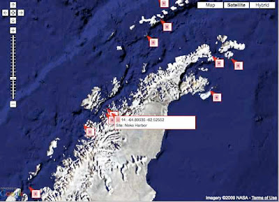
Jan 20 map

And here is the location of the beautiful Neko Harbor.

Leaving the Continent

I haven’t posted lately because the Drake Passage has made me a bit seasick. I’m wearing a patch, so it’s mild, but haven’t felt much like doing anything but lying in bed trying not to be sick. The seas are slightly calmer this morning, so I’ll just finish telling you what we did the afternoon of the 20th.

Headed to Dallmann Bay this afternoon where we saw many humpback whaled like this mother and calf. Some were using the bubble feeding method rarely seen in the Antarctic.


Then through Gerlache Strait and into the open waters of the Drake Passage.


Won't be seeing much of anything except sea birds for the next two days.

Tuesday, January 20, 2009

Fantastic Day!

Happy Inauguration Day! (Unfortunately, they only have Fox News available.)

And in Antarctica, this was perhaps the most glorious day of the trip. The location and weather were stunning. The kayaking, climbing, and tobogganing were a blast. Here's how it went.

I awoke to this view out my cabin window. We were on the Antarctic continent in a place called Neko Harbor in Andvord Bay.


The water was like glass.


Started the morning kayaking around the harbor for an hour. The view from water level was great.

The water was so clear that you could see much of the 90% of the iceberg that is under water.


Another kayak gives a little scale to the mountains.


A gentoo penguin swam up to check us out.


This photo was taken from the kayak, but it will come into play later. If you look to the right of the highest bare rock, you will see some trails heading down the hill.


So we land on shore and start the climb up. This penguin is leading the way.


I stopped part way up the hill to look at the view and found a penguin was taking a look around.


This rookerie on the hill had a great view of the harbor.


We decided to climb even higher.
And at the top, I posed for the shot everyone will be using for the Christmas cards next year. It was spectacular.
The trip down was the best, however. Many of us chose the fast way and tobogganed down on our rear ends. Who wants to walk down when you’re wearing slick rain pants? Very fun.

This was the last landing of the trip. It’s pretty much just sailing home from here which will take two days. Might not be much to write about for a while.

Ice, Whales, and Booth Island

Soon after crossing the Antarctic circle, the pack ice appeared and prevented us from moving further south. It was fun to crash through, however!


We turned around, headed back the way we came and saw a few humpback whales along the way. There’s a small fluke here if you look carefully.


Stopped at Booth Island where there is still quite a lot of snow. The surrounding mountains were beautiful. This landing was from 8-10 pm, so the light's a little low.


Finally saw our first leopard seal beached on some ice.


Because of all the snow, the penguins didn’t have much room to nest. We didn't see and chicks yet, either. Not sure what's going on.

Back on the ship for the night.

Monday, January 19, 2009

Antarctic Circle!

Crossed the Antarctic Circle this morning! Not many ships get to do this, they say, so it’s quite exciting. Here I am celebrating with my LabQuest in the Bridge.


That's a low latitude.

And the location on the map.

Sunday, January 18, 2009

Cuverville Island and Fog

Visited Cuverville Island this morning, beautiful and mountainous and home to this gentoo penguin rookerie.


In contrast to the large gentoo chicks from a few days ago, these are only one week old. So cute.


Walked around the island a bit and found this guy wandering by himself.


Icebergs can be dangerous due to flipping, but these were grounded and therefore safe for an up close and personal Zodiac cruise. I thought the dueling cameras were funny.


The shapes and colors were beautiful.


The rest of the day was a bit disappointing. We traveled to potentially the most beautiful part of the trip—Paradise Bay and the Lamaire Channel. Unfortunately, fog and snow moved in so we couldn’t see much of it. Paradise Bay supposedly has large mountains rising straight from the water. This is about all we saw.


In the center of this photo is the entrance to the very narrow and dramatic Lamaire Channel, often called the prettiest spot in Antarctica. The Antarctic mainland is on the left and Booth Island is on the right.


Inside the Lamaire Channel, you can see how narrow it is. We will return on our way back up, so perhaps we’ll get better weather then.


Still a great day.